SRGZ:
Stock
Gold:
Gold
Silver:
Stock

Star Gold Corp., is focused on developing and bringing to final permit Longstreet Gold & Silver Project in Nye County Nevada. The Project currently is focused on a small part of the property called the Main Zone. Historic drilling at Main has been twinned by Star Gold Corp, and a indicated resource has been established. See SK 1300 Resource Report


The Longstreet gold and silver project (the “Longstreet Project”) is located approximately 275 km (171miles) northwest of Las Vegas, Nevada; approximately 92 km (57 miles) northeast of Tonopah. Tonopah, the seat of government for Nye County, in west central Nevada is a town of approximately 2,500 people. The northeast‐southwest oriented property is situated within the McCann Canyon and Georges Canyon Rim 7 1/2 topographic quadrangles and extends approximately 3 km (1.9 miles) along strike within the Monitor Range. The geographic coordinates of the central part of the property are approximately 38°22′0″ N Latitude and 116°40′00″ W Longitude.
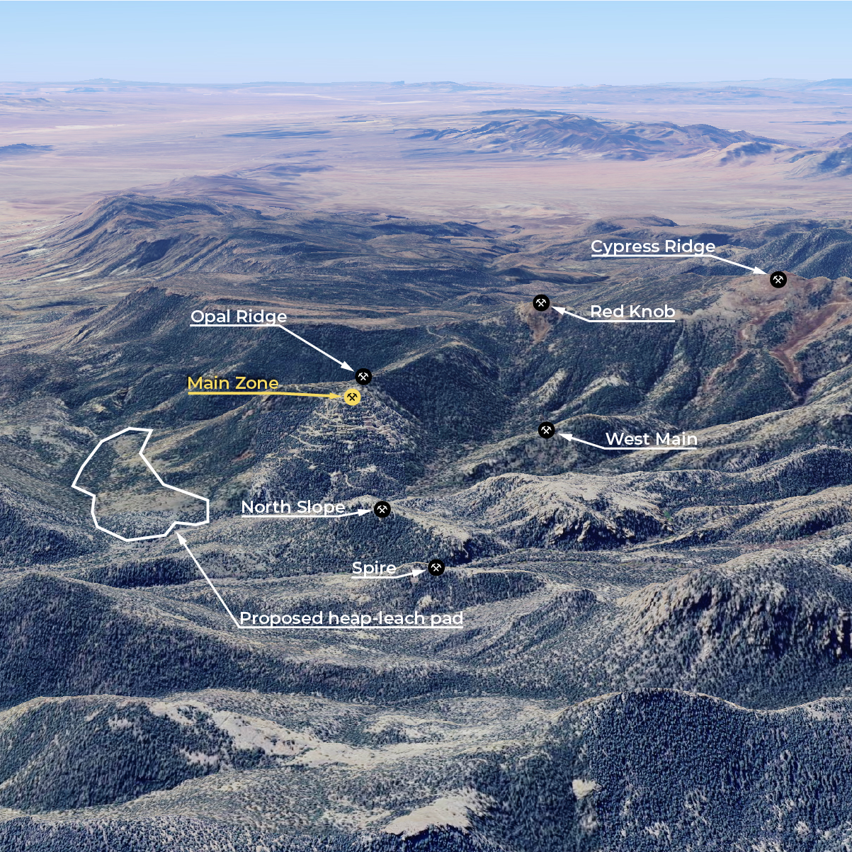
The Longstreet Project includes five (5) targeted sites including the Main, North, Opal Ridge, Cyprus Ridge and Red Knob zones. Star Gold’s geologist believes sampling and drilling results to date warrant optimism of one or more economic, near surface, bulk-mineable, heap leach recoverable gold and silver deposits at the target sites. Over the past 32 years, more than 403 reverse core (“RC”) holes totaling approximately 24,700 m (81,000 ft.) and 1,310 m (4,295 ft.) of diamond drilling in 19 holes have been completed by Star Gold and the property’s previous owners in the general area of the Longstreet Project. Most of the drilling was completed on the Main Zone and includes 16 RC holes drilled by Star Gold in 2011, along with 23 RC drill holes and 4 diamond drill holes completed by Star Gold in 2012. Three (3) of the 2012 RC holes explored the North Zone and 1 RC hole explored the Opal Ridge Zone.
Access
Access to the Longstreet Project is by two‐lane paved highway (Nevada HWY 6 to Warm Springs) approximately 48 km (30 miles) east from Tonopah, and then by gravel road (Stone Cabin Road) approximately 40 km (25 miles) north and a further 4 km (2.5 miles) west along a trail to Windy Canyon to reach the Longstreet property. The total distance from Tonopah to the property is approximately 92 km (57 miles). Supplies and heavy equipment are brought to the site by trucks, or other four‐wheel drive vehicles. There is no permanent camp at the site.
Climate
The Longstreet property lies within an area of low hills, with relief ranging from 750 m to 1,000 m (2,461 to 3,281 feet). The elevation in the general area ranges from 2,130 to 3,250 meters (6,988 to 10,663 feet) above mean sea level. The climate at Tonopah is semi‐arid with significant differences in seasonal temperature. The average temperature during the Winter months (November to March) is ‐5°C (23°F) and ranges from ‐10°C to +10°C (14°F to 50°F). The average temperature during the Summer months (April to August) is 25°C (77°F and ranges from 15°C to 35°C. (55°F to 95°F). The average annual precipitation is 15 cm (5.9 inches), mostly as snow during the Winter months, although there may be occasional rain during the Summer months. Exploration in the Longstreet area may be carried out throughout the year.
Property Geology
Geological mapping by Star Gold, and previous operators, indicates that the Longstreet property is underlain predominantly by Oligocene, moderately to poorly welded tuffs, with common lithic and pumice fragments. Past work also indicates that Au‐Ag mineralization occurs almost exclusively within the welded tuffs. Gold and silver mineralization on the Longstreet property is typical of low‐sulphidation epithermal Au‐Ag systems associated with hydrothermal alteration assemblages within felsic volcanic rocks. These deposits are formed at relatively shallow depth, typically within a hundred meters (3,937 feet) of the surface, from hydrothermal fluids with temperatures of less than150°C to 300°C (302°F to 572°F)
Environmental, plan of operation and reclamation
To the Star Gold’s knowledge, there is no surface disturbance or groundwater contamination from previous mining activities. Star Gold has, during its tenure, conducted remediation activities immediately after completion of its exploratory drilling. With respect to historical mining activities, there is no indication, at this time, that reclamation is needed and therefore Star Gold has no plans to remediate the property except in relation to its own activities when warranted. The Longstreet property is within U.S. Forest Service lands and Star Gold has applied for and received a Plan of Operation from the Forest Service allowing exploration drilling. A surface disturbance bond of $89,400 has been paid and is held by the Forest Service until reclamation is completed. There are no other significant environmental requirements.